
AJ Jones is a writer and creator of art, expressing herself across different mediums. She embraces her neurodivergence as a unique way to view the world in hopes of creating a better future. She first published this essay on her Substack newsletter, Blue Dot Thoughts.
On Memorial Day I set out to visit Iowa’s largest “lake.” A staple in the memories of my youth. I was curious to see if people still relaxed and recreated as they once did during the warm weather holidays. So much has changed, environmentally, since I was a kid and not for the better.
It seems I was born in the “sweet spot.” A time before an outrageous number of CAFOs (Concentrated Animal Feeding Operations) and manure run-off…a time before Roundup and glyphosate. A time of innocence when family and friends could meet at Iowa lakes to fish, to swim, to enjoy the warmer seasons outdoors.
Looking back we had no idea just how lucky we were.
Memories…
Growing up in Marion County our nearest “beach” was Roberts Creek. I can still smell Mom’s homemade suntan lotion; drops of iodine added to baby oil. The bottle reminiscent of a lava lamp as the fluids of differing viscosity separated between shakes. The concession stand on the hill that served pop in heavily-waxed, red, white and blue, paper Pepsi cups. A huge swath of sand that delighted me when I dug my toes deep and repulsed me when I could not adequately remove the loose particles from my skin.
It was also at Roberts Creek the first time I really bonded with my soon-to-be step-father. My little feet in his large hands as he launched me into the air…the moment of flight…the delight of diving into the water…the laughter as I squealed, “Again!”
Both Mom and Lee have since passed; memories serve as tender touchstones.
To my surprise, and possibly my naivete, the beach at Roberts Creek I remember from childhood no longer exists. From across the water I could see the much younger trees growing in the general location of where the beach once was. Judging by the trunk size I am guessing the flood of 1993 was the end of the beach. The passage of time and the reflection of memories is often bittersweet.
A waterway by any other name…
According to the Iowa Department of Natural Resources, Roberts Creek, located between Knoxville and Pella in Marion County, is actually a lake fed by Wildcat Creek. According to Tracy Spry, a retiring park ranger with the U.S. Army Corps of Engineers Rock Island District, Lake Red Rock is actually a reservoir. Spry described Roberts Creek as a sub-impoundment, meaning as waters in the reservoir rise, the excess backs up through a culvert under G-28 that runs between the reservoir and Roberts Creek.
Red Rock Lake, as it is known, is Iowa’s largest lake covering anywhere from 15,000 acres (its usual size) to 70,000 acres (which happened during the flood of 1993).
Taming a wild river to create Red Rock Lake
According to the U.S. Army Corps of Engineers website: “Construction of the Red Rock Dam began in 1960, and the dam was finished in 1969. The primary purpose of the dam is to reduce flood damage along the Des Moines River below the dam, as well as along the Mississippi River further downstream.” (Before the Red Rock Dam was built, the Des Moines River experienced significant flooding, particularly in the years 1851, 1859, 1903, 1944, 1947, and 1954.)
In addition, excavation work began in July 1965 at Saylorville Lake further north along the Des Moines River near Johnston. The dam was completed in 1971 and, according to Spry, designed to work in conjunction with Red Rock Dam.
Residents who were to be displaced by the new “Red Rock Lake” received money for their land, gathered their belongings and left to start new lives elsewhere. Their homes, churches, schools were torn down. It only took four days for the lake to fill. Much sooner than anyone had anticipated.

One of the last remaining artifacts of the town of Red Rock. Located at the Lake Red Rock Visitor Center

The plaque beneath the church bell
I am left with a feeling of deep respect and reverence for the minds who calculated, designed, and completed all the math, engineering and logistics involved. What an absolutely remarkable feat.
Beneath the murky depths…
I had just finished watching a recently posted YouTube video (below) when Tracy Spry returned my call for an interview. Excitedly, and more than a little disturbed, I asked if the cemeteries of the six towns flooded when the dam was created were still…down there. She assured me, quite adamantly, that the cemeteries had been relocated to spots selected by the living family members. Moreover, she could look up the name and new location of each gravesite.
I described the Iowa PBS video I had watched. She explained she had not been contacted by Iowa PBS and knew nothing of the YouTube video.
Fair enough, and yet, was it possible that not every gravesite had been relocated for one reason or another? The video claims the remains of about 60 people now rest in watery graves. Could both be true? I shudder to think of the way the answer to this mystery might one day…surface.
A tale of two tests…
Armed with my childhood memories, the new information gleaned from Spry, and a nitrate test kit, I set out on my journey. Since there is no set entry point to Lake Red Rock, I ended up at the exit just below the dam at the North Tailwater Recreation Area.
People were setting up for picnics as children played nearby. Many people were fishing along the banks. Others were walking and taking pictures; leisurely enjoying the day.
I tested the water right below Red Rock Dam for nitrates. The results so ghastly I tested twice to be certain I hadn’t done something wrong.
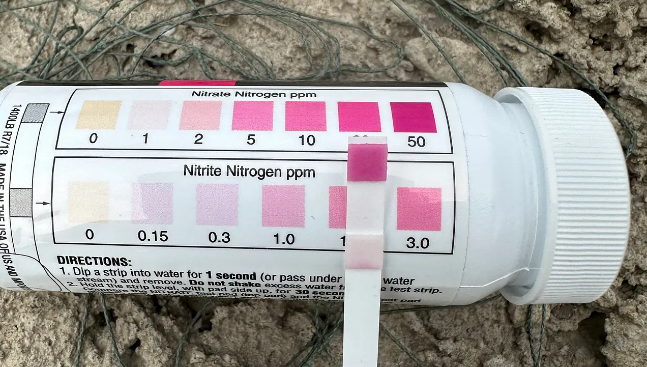
Nitrate test just below Red Rock Dam
Later, out of curiosity, I tested the water at Roberts Creek. It is fed (except when there is excessive rain and the reservoir rises) by Wildcat Creek. I was pleasantly surprised by the results.
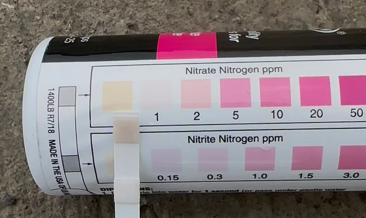
Roberts Creek nitrate test
But how could two bodies of water, not exactly, mutually exclusive yield such different results? A quick look at what and where red flags exist gave me a pretty good idea.
This is why we can’t have nice things…
1. This map of Iowa CAFOs, created by the Environmental Working Group, speaks for itself.

The Des Moines River as it runs through Iowa. A rough visual overlay of these maps is self-explanatory when horrific water quality is a topic of discussion.
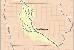
Source: Wikipedia Des Moines River map
2. Glyphosate (Roundup) usage. (2019)

Source: USGS (A bit blurry…happens when zooming in for a closer look)
Monsanto introduced farmers to glyphosate via Roundup in 1974. (Bayer acquired Monsanto in 2018.)
According to Rebel Pastures, a regenerative farming operation based in Michigan,
In 1996, “Roundup Ready” or GMO crops were introduced and glyphosate sales exploded. Farmers could now spray this chemical right on their crops to kill weeds without damaging the crop at all. In addition, the use of glyphosate surged due to more frequent applications, increased usage across various fields, and higher quantities being applied each time.
Water, water, everywhere, and…
The use of glyphosate on the fields of Iowa (and elsewhere) as well as the manure that seeps into the soil and waterways from too large, environmentally mismanaged CAFOs lead to nitrogen and E. coli imbalances. This is the albatross hanging from the necks of Iowans — present and future — representing the (immorally unhealthy) environmental transgressions and the consequences of those actions.
We need to do better. We can do better…starting with raising awareness; electing people into office who care about the health of the people in ways that include stewardship of land and water.
Water quality is key…
I urge everyone who cares about water quality in Iowa, and elsewhere, to join in any way you can. This isn’t just a battle for the now…it is a battle for the future of those who will follow. If not us…who?
Click here to learn more about the Driftless Water Defenders 48 Lakes Initiative and how you can get involved.
3 Comments
Glyphosate has been greatly overused by Iowa industrial agriculture...
…and that deserves to be called out, so thank you, AJ Jones. The jaw-dropping nitrate levels in Iowa waters, however, are primarily caused by human-degraded soils that can no longer hold onto nutrients, the use of more nitrogen fertilizer than crops can use or degraded soil can hold in place, and of course the ocean of manure produced by CAFOs. And a lot more credit goes to the absence of badly-needed farm conservation practices, especially cover crops.
In Iowa, a small minority of dedicated farmers and landowners do really wonderful farm conservation, and they deserve public thanks for it. The majority of Iowa’s farmers and landowners sort of kind of try to politically hide behind that minority.
It should also be noted that Iowa reservoirs started filling in soon after being built because of Iowa’s massive soil erosion, which also causes phosphorous pollution and toxic algae blooms. And farmland erosion continues. The Army Corps of Engineers did a 2011 survey of how fast the Red Rock conservation pool is filling in. That survey is not cheery reading.
It was very nice to see, in this post, recognition of the human costs of Iowa reservoirs. I was told years ago about one landowner who was never the same person after her cherished woodland was drowned by Saylorville Lake. A friend who was familiar with the natural areas in the valley drowned by Saylorville said that he and others also had trouble dealing with the losses, which were extensive, including the damage to Ledges State Park.
Certainly Iowa reservoirs brought benefits, especially flood damage relief, as pointed out in this post. But there are good reasons why, in most parts of the world, the building of large reservoirs has now fallen out of favor.
Thank you for this post, AJ Jones.
PrairieFan Fri 6 Jun 2:52 AM
Whoops, sorry, one more...
Another major cause of Iowa’s nitrate pollution is Iowa’s farm drainage system. Iowa has more tile-drained land than any other state by far, and those many thousands of miles of tile have largely become a fast route for nutrient pollution to reach water. More tile is being installed in Iowa farmland every year.
PrairieFan Fri 6 Jun 9:38 AM
Todd is trying his best to shift Sand
toward doing something meaningful against corporate interests but so far he’s sticking to his old form:
https://www.thegazette.com/staff-columnists/sand-sticks-up-for-exira-but-isnt-ready-to-talk-about-ag-pollution/
dirkiniowacity Sun 8 Jun 1:21 PM